Satellite Data Reveals the Scale of Iran’s Collapsing Water Infrastructure
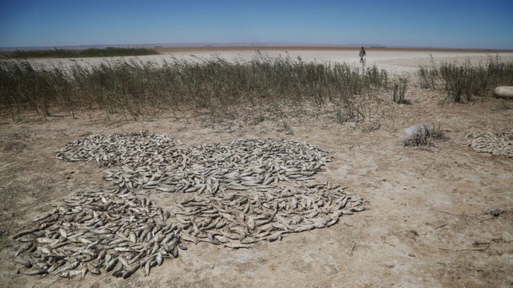
Table of Contents
The View from Orbit: A Landscape in Retreat
For decades, the scale of Iran’s environmental degradation was a matter of local reporting and fragmented data. Now, high-resolution satellite imagery is providing a stark, undeniable record of a country running out of water. The most visceral evidence is found in northwestern Iran, where Lake Urmia—once the largest saltwater lake in the Middle East—has effectively vanished. In the 1990s, the lake spanned nearly 6,000 square kilometers; today, it has shrunk to just 581 square kilometers, leaving behind vast, caustic salt flats that threaten the health of surrounding populations.
This is not merely a result of a changing climate. The collapse is the product of a systemic failure in water management. Over 60 dams were constructed on the lake’s feeder rivers, choking off the primary inflows. This, combined with aggressive groundwater extraction and the diversion of water into inefficient agricultural channels, has created a deficit that nature cannot replenish.
The Tehran Water Trap
The crisis is most acute where the population is densest. Satellite monitoring of the Lar, Latyan, and Mamloo dams—the primary lifelines for Tehran—shows a consistent and alarming decline in water levels. The capital, home to over nine million people, is currently operating on a precarious margin. The tension is exacerbated by a geographical imbalance: roughly 75% of the Iranian population is concentrated on less than 40% of the land, placing an unsustainable demand on a few specific watersheds.
The technical failure is rooted in the efficiency of the grid. Agriculture consumes approximately 91% of Iran’s water withdrawals. However, much of this is lost to antiquated irrigation systems and leakage in the distribution network. While the state has focused on dam construction as a primary solution, the data suggests that storage cannot compensate for the lack of sustainable replenishment. In 2025, the national water consumption reached approximately 100 billion cubic meters—roughly 13 billion cubic meters beyond the country’s renewable capacity.
Infrastructure Under Fire
The fragility of the system has been pushed to a breaking point by recent geopolitical instability. Reports indicate that civilian water infrastructure, including desalination plants and critical pipelines, sustained damage during the early stages of the US-Israel conflict in Iran. For a nation already classified by the World Resources Institute as facing “extremely high” baseline water stress, the loss of even marginal infrastructure can trigger localized catastrophes.
Unlike its Gulf neighbors, who have invested heavily in massive desalination grids, Iran’s reliance on this technology is minimal, accounting for only about 3% of its water needs. Because the existing plants are clustered along the southern coast, the inland heartlands—including Isfahan and Tehran—remain entirely dependent on surface and groundwater, leaving them vulnerable to both drought and sabotage.
The Rise of the Climate Refugee
The technical collapse of the water table is now driving a demographic shift. Abdolkarim Hosseinzadeh, Iran’s vice president for Rural Development and Disadvantaged Regions, notes that only 38,000 of the country’s 69,000 villages remain inhabited. The abandonment of 31,000 villages is a direct consequence of wells running dry and the soil becoming unarable. This has created a wave of internal migration toward already strained cities like Mashhad and Shiraz.
The symbolic death of these waterways is best captured by the Zayandehrud River. Once the lifeblood of Isfahan, satellite imagery of the Zayandehrud Dam now shows receding waters, while the historic Allahverdi Khan Bridge, which once spanned a rushing river, now frequently arches over a dry, cracked bed. The imagery confirms that the crisis is no longer a future projection; it is a current, systemic reality.