Mindanao Earthquake: 7.8 Magnitude Tremor Triggers Tsunami Warnings and Massive Infrastructure Failure
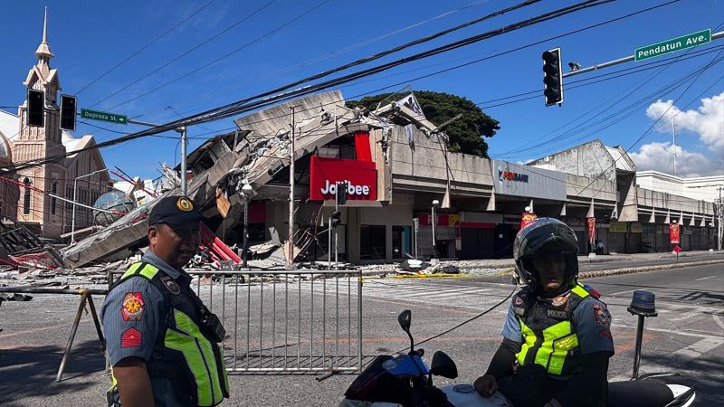
Table of Contents
Devastation in Mindanao
A massive 7.8 magnitude earthquake struck the southern Philippines on Monday morning, leaving a trail of destruction across the Mindanao region. The quake, which hit at 07:37 a.m. local time, centered near General Santos City in Sarangani province, causing immediate structural failures and triggering widespread panic across the archipelago.
According to the United States Geological Survey (USGS), the tremor occurred at a depth of approximately 35 kilometers (21.7 miles). The scale of the event has already resulted in at least 19 confirmed deaths and over 200 injuries. The most severe casualties were reported in Sarangani province, where disaster authorities confirmed that a landslide triggered by the seismic activity claimed 13 lives.
Infrastructure Collapse and Schoolyard Chaos
The timing of the quake coincided with the start of the new academic year, placing thousands of students in precarious positions. In Davao Occidental and Davao Del Sur, social media footage captured elementary students crouching in terror as the ground shifted violently. At Matanao National High School—a facility already compromised by seismic activity in 2019—the structure completely collapsed during the tremor.
In the urban center of General Santos City, the impact was visible in the failure of commercial infrastructure. Reports and imagery from the local information office show convenience stores reduced to rubble and concrete slabs pancaking. A Jollibee fast-food outlet suffered a partial collapse, while the local police headquarters in Alabel reported significant structural cracking. Regional emergency official Ednar Dayanghurang noted that in Davao City alone, more than 100 students suffered bruises or fainted during morning flag-raising ceremonies due to the intensity of the shaking.
The Seismic Context of the Ring of Fire
The Philippines, along with Indonesia and Japan, sits atop the Pacific Ring of Fire, a volatile arc of subduction zones and fault lines. This geographical positioning makes the region one of the most seismically active areas on Earth. This event follows a devastating pattern; only last year, a major quake on the central island of Cebu killed at least 74 people, marking a trend of increasing instability in the region’s geological strata.
The Philippine Institute of Volcanology and Seismology (PHIVOLCS) reported that the initial shock was followed by a staggering 138 aftershocks. These secondary tremors continue to pose a risk to already weakened structures, complicating rescue efforts and evacuation protocols.
Regional Tsunami Alerts and Emergency Response
The magnitude of the displacement triggered immediate tsunami warnings across the Pacific. President Ferdinand Marcos Jr. issued an urgent directive for residents in coastal provinces to move to higher ground immediately, emphasizing that life must take precedence over salvaged property.
The Pacific Tsunami Warning Center monitored the event closely, reporting that smaller waves were recorded as far as Indonesia, Palau, and southern Japan. While the National Weather Service confirmed there was no threat to Hawaii and the primary tsunami risk subsided roughly five hours after the initial quake, officials have cautioned that sea levels may continue to fluctuate.
President Marcos Jr. has mobilized all relevant government agencies to coordinate rescue operations and provide immediate relief to the affected provinces. Philippine Red Cross workers have been deployed to the hardest-hit areas of Mindanao to survey collapsed buildings and assist in the recovery of missing persons.