LiDAR and High-Volume Drainage: The Technical Race to Rescue Trapped Miners in Laos Caves
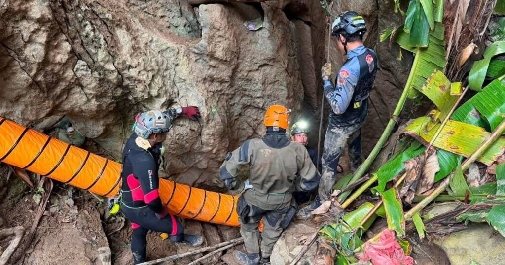
Table of Contents
Engineering Against the Clock in Xaisomboun
In the rugged terrain of Xaisomboun province, Laos, a high-stakes rescue operation has evolved into a complex engineering challenge. After more than a week of flash flooding and claustrophobic conditions, international teams are fighting to locate two remaining men trapped within a sprawling, mazelike cave network. While five survivors have already been recovered—four of whom managed a self-evacuation on Saturday—the final two are believed to be lodged deeper in the system, where the margin for error is nearly zero.
The operation is not merely a feat of physical endurance but a deployment of specialized technology designed to map an invisible environment. At the center of the effort is a multinational coalition of divers and engineers from France, Australia, Finland, Malaysia, Japan, and Indonesia. They are utilizing LiDAR (Light Detection and Ranging) to create precise 3D terrain maps of the cave’s interior, allowing rescuers to identify potential air pockets and structural bottlenecks without relying solely on the guesswork of divers in zero-visibility water.
The Mechanics of Survival: Drainage and Air Layers
The primary obstacle is water. Heavy seasonal rains in Laos turned the cave’s entrance into a blockade, trapping seven gold prospectors. To counter this, the rescue team is employing a strategy of simultaneous cave drainage. By aggressively pumping water out of specific chambers, the team is not only clearing paths for divers but actively creating “air layers”—pockets of breathable atmosphere that can sustain the trapped men if they are located in higher sections of a chamber.
Kengkard Bongkawong, a Thai specialist cave diver from the Mettatham Association Rescue Unit, is leading the operation. Bongkawong is no stranger to the psychological and technical toll of these missions, having played a pivotal role in the globally publicized 2018 rescue of the youth soccer team in Thailand’s Chiang Rai province.
“The discouraged and tired feelings are a lot,” Bongkawong told NBC News, reflecting on the immense pressure of the operation. His current strategy involves a refusal to be dictated by the environment, focusing on building an infrastructure of ponds and roads to facilitate the drainage system. “I will not let the nature control me, I will control the nature,” he stated.
The Deep-Shaft Search
As of Monday, the search has pivoted toward deep-shaft exploration. Divers have rappelled over 160 feet into the cave’s depths, using acoustic signaling—specifically striking rock walls with hammers—to elicit a response from the missing men. This method of seismic communication is often the last resort when electronic equipment fails due to the density of the limestone and the presence of standing water.
The technical difficulty is compounded by the risk of reflooding. The same seasonal weather that trapped the men continues to threaten the stability of the drainage efforts. Any sudden surge in rainfall could neutralize the progress made by the pumps, effectively erasing the air layers the team has worked to establish.
A Dangerous Draw: The Mining Incentive
The incident underscores the perilous intersection of artisanal mining and environmental volatility in Southeast Asia. Despite official warnings, the men—all locals—entered the caves in pursuit of gold. While Laos maintains a commercial mining sector for copper and gold, the allure of unregulated prospecting often leads individuals into dangerous cave networks that are otherwise prized as tourist attractions.
The rescue remains in a state of high tension. While the successful extraction of the first five men provided a critical proof-of-concept for the drainage and mapping strategy, the remaining two are in an environment where the air is thinning and the geography is unknown. The mission now rests on the ability of the LiDAR data to pinpoint a location and the pumps to keep the water at bay long enough for a diver to make contact.