Advanced Mapping and Vertical Shafts: The High-Stakes Technical Battle to Rescue Trapped Miners in Laos
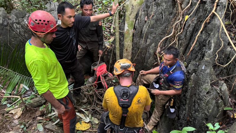
Table of Contents
The Precision Challenge of Subterranean Extraction
In the dense jungles of central Laos, a specialized international team of divers and engineers is fighting a battle against both geology and hydrology. The objective is a high-stakes extraction of two men trapped within a complex, flooded cave network—a mission that has evolved from a standard search into a sophisticated technical operation involving advanced subterranean mapping and vertical shaft exploration.
The crisis began on May 20, when eight men entered the cavern in search of gold. Heavy monsoon rains triggered flash floods, transforming the narrow limestone tunnels into lethal conduits of water and silt. While five men managed to escape—some aided by experts and others through sheer endurance—two remain missing. The rescue is now pivoting toward the use of high-resolution scanning equipment to visualize the cave’s interior, as traditional navigation has proven impossible due to the opacity of the floodwaters.
The Vertical Shaft Gamble
The focus of the operation recently shifted toward a newly discovered vertical shaft, which rescuers hoped would provide a direct bypass to the chambers where the missing men might be sheltering. Thai specialist cave diver Kengkard Bongkawong and technician Manat Artmongkron initially reported hearing rhythmic knocking sounds approximately 70 meters down the shaft—a classic indicator of survivor signaling.
However, the technical reality of the shaft has proven daunting. Australian diver Josh Richards later cautioned that these auditory signals could be misinterpretations of natural phenomena, such as wind currents or bat activity, citing the acoustic anomalies common in fissured limestone environments. More critically, the shaft appears to be obstructed by significant rockfall and landslide debris, rendering it impassable for human divers without extensive excavation.
Mapping the Invisible
To overcome the lack of visibility, the team is awaiting the arrival of advanced scanning equipment capable of producing a digital map of the cave’s layout. Because the current maps are based on the fragmented recollections of the five survivors, the margin for error is dangerously high. Kengkard Bongkawong noted that deploying these scanners while rappelling down vertical shafts could provide the granular data needed to identify air pockets or unexplored chambers where survivors might be trapped.
The operation is further complicated by the hydrostatic pressure of the monsoon season. The team is employing heavy machinery to dig water retention ponds, allowing them to pump out massive volumes of water from the cave system to lower the water table. Bongkawong likened the cave’s current state to a ‘straw,’ where any sudden rainfall instantly fills the narrow conduits, creating a lethal trap for both the victims and the rescuers.
Operational Constraints and Logistics
The rescue effort is a synthesis of international expertise, featuring divers like Mikko Paasi from Finland and specialists from Thailand and Australia. The logistics are precarious; rescuers are operating in a cycle of intense activity followed by critical rest periods to manage the physical toll of deep-cave diving and rappelling. As of the latest updates, the team is prioritizing the continued drainage of the cave to create a safe window for re-entry.
The survival of the first five men—who endured over a week on minimal water and strategic sleep—provides a slim margin of hope. However, the transition from a rescue mission to a recovery operation depends entirely on the efficacy of the incoming mapping technology and the stability of the cave’s vertical structures.