BlackSky Accelerates NRO Partnership to Build ‘AI-Ready’ Broad-Area Surveillance Fleet
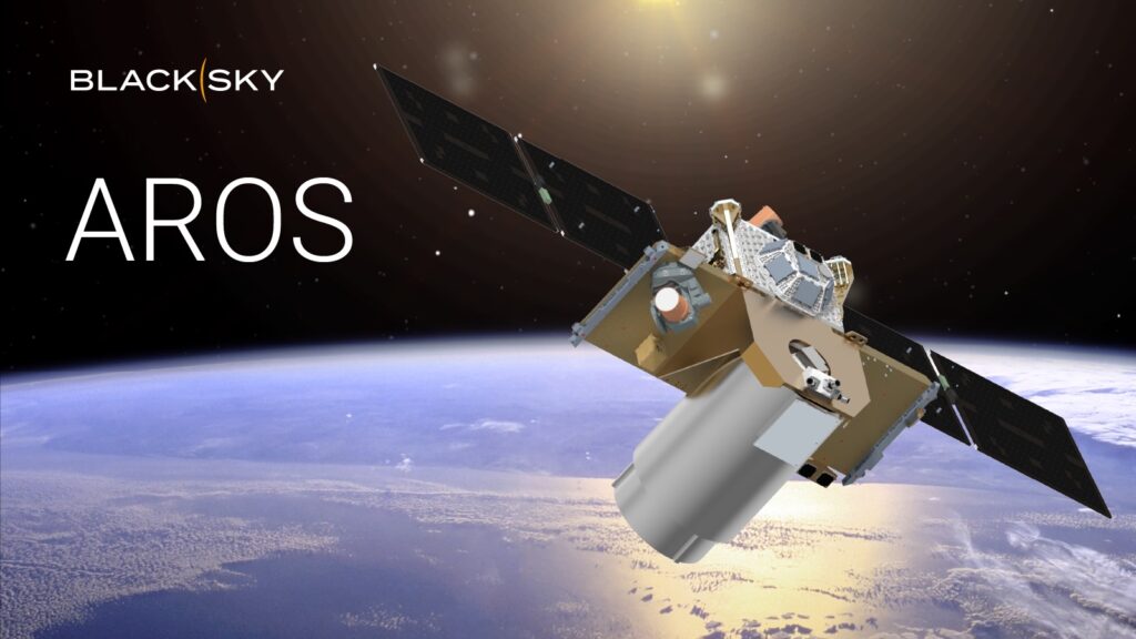
Table of Contents
The Push for Wide-Angle Intelligence
The National Reconnaissance Office (NRO) has moved to accelerate the development of a new class of surveillance capabilities, awarding a contract modification to BlackSky Technology. The move is designed to fast-track the deployment of the AROS (Advanced Reconnaissance and Observation System) broad-area-collection satellites, focusing on a capability that the U.S. government views as critical for maintaining a competitive edge in global space intelligence.
According to a June 9 announcement, the modification establishes a direct development path toward a flight-ready, multi-spectral, large-area mapping spacecraft. The goal is to have a fully operational foundation data collection system in orbit by 2028. While the NRO has not disclosed the specific financial value of the modification, the strategic intent is clear: the U.S. needs a more resilient and agile way to monitor vast geographical swathes in near real-time.
Solving the ‘Tip and Cue’ Dilemma
In the world of geospatial intelligence, there is a constant trade-off between resolution and coverage. High-resolution satellites can see a specific vehicle clearly, but they have a narrow field of view—essentially looking through a straw. Broad-area collection satellites, conversely, can monitor entire regions or coastlines but lack the granular detail needed for positive identification.
BlackSky’s AROS constellation is designed to bridge this gap through a “tip and cue” operational model. The AROS satellites will act as the wide-angle lens, scanning massive areas for anomalies—such as an unexpected gathering of naval vessels or a sudden shift in aircraft movements. Once a point of interest is detected, the system will automatically “cue” BlackSky’s higher-resolution Gen-3 satellites to pivot and capture detailed imagery of the specific target.
This tandem operation, powered by AI-enabled analytics, allows for the automated detection and characterization of vehicles and vessels without requiring a human analyst to manually scan thousands of square miles of raw imagery.
The AI Pipeline and Digital Twins
The AROS project isn’t just about hardware in orbit; it’s about the data pipeline on the ground. BlackSky is leveraging its Gen-3 architecture and vertically integrated manufacturing to create what it describes as an “AI-ready” foundation. This includes a proprietary data pipeline designed to handle the massive volume of information generated by broad-area scanning.
One of the more ambitious goals mentioned in the rollout is the creation of 3D digital twins of the Earth. By combining multi-spectral mapping with retrospective AI analytics, BlackSky aims to provide decision-support tools that don’t just show where something is now, but how a landscape or logistics hub has evolved over time. This capability is expected to expedite the production of navigation safety applications and automated feature extraction, reducing the time between data capture and actionable intelligence.
Filling the Commercial Gap
The timing of the AROS deployment is not accidental. Brian O’Toole, CEO of BlackSky, noted that the system is intended to fill anticipated gaps in the market as aging commercial large-area collection satellites begin to decommission. As commercial foundation data becomes more capacity-constrained, the U.S. government is increasingly relying on hybrid models—mixing classified government assets with agile, commercially developed constellations.
By integrating the AROS constellation into the existing BlackSky fleet, the company is essentially offering the NRO a scalable, software-defined surveillance network. The ability to launch and update these systems rapidly—rather than relying on the decade-long development cycles of traditional monolithic spy satellites—represents a fundamental shift in how the U.S. approaches space-based reconnaissance.