7.8 Magnitude Quake Strikes Southern Philippines, Triggering Tsunami Alerts Across Pacific Ring of Fire
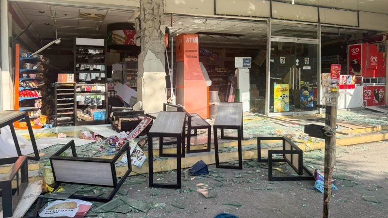
Table of Contents
Sarangani Province Braces for Aftershocks and Tsunami Surge
A massive 7.8 magnitude earthquake struck the Mindanao region in the southern Philippines on Monday morning, triggering immediate tsunami warnings across the archipelago and alerting neighboring nations in the Pacific. The seismic event, recorded at approximately 07:37 a.m. local time, originated at a depth of roughly 35 kilometers (21.7 miles), according to data released by the United States Geological Survey (USGS).
The epicenter was located off the coast of General Santos City in Sarangani province, situated at the southernmost tip of Mindanao island. The sheer force of the tremor caused immediate structural failures in urban centers; early reports and imagery from the local information office in General Santos City depict crumbling convenience stores and partially collapsed commercial buildings. In Alabel town, the quake was so severe that it interrupted a police flag-raising ceremony. Benjie Ancheta, the local police chief, confirmed to Reuters that the police headquarters sustained visible cracking and that several individuals fainted from the shock of the tremor, though no immediate casualties have been confirmed.
Regional Tsunami Alerts and Emergency Mobilization
The Philippine Institute of Volcanology and Seismology (Phivolcs) quickly issued a tsunami warning, urging residents in coastal zones to evacuate to higher ground. According to the US Tsunami Warning System, potential waves could reach heights of 1 to 3 meters above normal tide levels in certain coastal areas of the Philippines.
The crisis has extended beyond Philippine borders. Indonesia issued a tsunami warning for its northeastern coast, and the Japan Meteorological Agency placed a tsunami advisory for Japan’s southern coastline, stretching from Ibaraki Prefecture to Okinawa Prefecture. Conversely, the National Weather Service has confirmed that no tsunami threat has been detected for Hawaii.
President Ferdinand Marcos Jr. has moved the government into an emergency posture, directing all relevant agencies to initiate rescue operations and forced evacuations. In a direct appeal to citizens in the affected provinces, Marcos emphasized the urgency of the situation: “Please heed the tsunami warning. Move to higher ground now. Do not wait. Your life is more important than anything left behind.”
The Volatility of the Ring of Fire
The magnitude of this event underscores the inherent geological instability of the region. The Philippines, Indonesia, and Japan are all situated along the “Ring of Fire,” a massive horseshoe-shaped belt of tectonic activity and volcanic eruptions circling the Pacific Basin. This area is characterized by subduction zones where tectonic plates collide, often leading to high-magnitude megathrust earthquakes like the one experienced today in Sarangani.
Sarangani province, which is currently the hardest hit, is home to roughly 580,000 people. The combination of shallow depth and high magnitude makes the region particularly susceptible to severe surface shaking and the displacement of seawater, which drives the tsunami risk.
As emergency crews begin to survey the damage in General Santos City and surrounding rural areas, the primary focus remains on the potential for secondary disasters, including landslides in the mountainous interior of Mindanao and the arrival of tsunami surges along the coast.