7.8 Magnitude Earthquake Devastates Southern Philippines; Tsunami Alerts Triggered Across Pacific
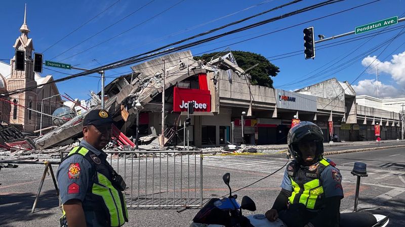
Table of Contents
Southeastern Mindanao Rocked by Massive Tremor
A powerful 7.8 magnitude earthquake struck the southern Philippines on Monday morning, sending shockwaves through the Mindanao region and causing significant structural damage in and around General Santos City. The quake, which hit at 7:37 a.m. local time, occurred at a depth of approximately 35 kilometers (21.7 miles), according to data from the United States Geological Survey (USGS).
The timing of the disaster coincided with the start of the new academic year, as thousands of students were returning to classrooms. In Davao Occidental, social media footage captured the chaos as elementary students were forced to crouch in open areas while the ground swayed violently. In Davao Del Sur, the roof of a high school campus collapsed while students were assembled on the sports field. While these specific incidents did not result in reported injuries, the psychological impact on the student population is expected to be profound.
Infrastructure Collapse and Casualties
The Office of Civil Defense has confirmed several deaths, though official casualty counts remain fluid as first responders struggle to reach isolated areas of Sarangani province. In General Santos City, images have emerged of crumbled convenience stores and partially collapsed commercial buildings. A notable point of impact was a Jollibee fast-food restaurant, which suffered a partial collapse, drawing immediate police cordons to the scene.
The severity of the shaking was felt even by law enforcement. Benjie Ancheta, police chief of Alabel town in Sarangani, reported that the local police building developed structural cracks during the morning’s flag-raising ceremony. Speaking via phone to Reuters, Ancheta described the event as the strongest earthquake the region has ever experienced, noting that several officers and civilians fainted from the intensity of the tremor.
Pacific Tsunami Alerts and Regional Response
The scale of the seismic event triggered immediate tsunami warnings across three nations: the Philippines, Indonesia, and Japan. This rapid response underscores the volatility of the “Ring of Fire,” the horseshoe-shaped belt of tectonic activity that encircles the Pacific Basin and makes this region one of the most seismically active on Earth.
President Ferdinand Marcos Jr. issued an urgent directive to government agencies to prioritize evacuations and rescue operations. In a direct address to citizens in the affected provinces, Marcos urged residents to prioritize their lives over possessions, stating, “Please heed the tsunami warning. Move to higher ground now. Do not wait.”
By early afternoon, the Pacific Tsunami Warning Center indicated that the immediate threat had largely subsided, roughly five hours after the initial shock. However, authorities cautioned that sea levels could continue to fluctuate, which can create dangerous currents for coastal communities. The National Weather Service confirmed that no tsunami threat was detected for Hawaii.
The Seismic Context of Sarangani
Sarangani province, home to roughly 580,000 people, has become the epicenter of the current crisis. The Philippine Institute of Volcanology and Seismology (Phivolcs) noted that the quake occurred off the shores of General Santos City, a critical economic hub for the southernmost tip of Mindanao. Because of the region’s geography and the shallow depth of the quake, the surface intensity was significantly magnified, leading to the widespread structural failures observed in the city’s urban core.